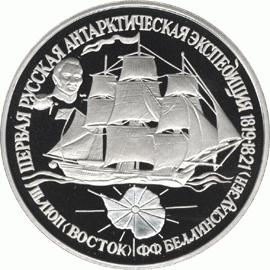
Bellingshausen and Lazarev: discovery of Antarctica. F. Bellingshausen - discoverer of Antarctica Thaddeus Faddeevich bellingshausen Antarctica
“Vostok” and “Mirny” left Kronstadt in the summer of 1819. The first ship was commanded by Thaddeus Bellingshausen, the second by Mikhail Lazarev. By that time, both of them had already proven themselves as experienced sailors: Lazarev, for example, with the crew of the Suvovorov ship reached Sydney, and Bellingshausen participated in a circumnavigation of the world. Now they were faced with a difficult task - finally the southern continent, the existence of which geographers of that time only guessed.
Assumptions that there should be a large piece of land near the south pole began to appear among sailors back in the 16th century. However, until the beginning of the 19th century, it was believed that it was virtually impossible to prove its existence due to incredibly difficult weather conditions. “The cold was so strong that none of our flotilla could bear it,” wrote the Florentine traveler Amerigo Vespucci, who allegedly ended up on the island of South Georgia, which lies one and a half thousand kilometers from Antarctica. The second reason why no one tried to reach Atlantis for a long time is that this land - quite naturally for that time - was considered practically useless.
"Vostok" and "Mirny" before sailing in Kronstadt. (infourok.ru)
Nevertheless, certain attempts were made to explore the mainland: the British, for example, sent an expedition led by James Cook to the Antarctic Circle. His ships, going further and further south, encountered impassable ice cover, which is why they were forced to turn around. Cook then decided that no continent simply existed in those lands.
In Russia, the idea of exploring the Southern Arctic Circle was primarily promoted by the famous traveler and navigator Ivan Kruzenshtern. There is even evidence that Kruzenshtern himself wanted to lead the expedition, but still refused, citing his advanced age and health problems. In the government, the responsible ministers liked the idea of the first Antarctic expedition: in a hurry - it was impossible to allow other countries to get ahead of the Russian sailors - preparations for the voyage began.

The ship's crew examines the iceberg. (klin-demianovo.ru)
The ships “Vostok” and “Mirny”, which Lazarev and Bellingshausen received at their disposal, were not designed for navigation in ice. Even though these were relatively new vessels, the crews were constantly faced with leaks and hull failures. The crew was formed exclusively from volunteers—by the way, there were quite a few of them, about 200 people. Also on board were university professors, an artist and a hieromonk.
The mission of the expedition was formulated very briefly and precisely: the sailors were instructed to “continue their research to the most distant latitude that can be reached.” “Vostok” and “Mirny”, having proceeded through Portsmouth and Rio de Janeiro, reached the island of South Georgia - it lies two thousand kilometers east of the Argentine coast. The team began research and made an inventory of the shore, secretly discovering another small island - it was later named in honor of the navigator, one of the lieutenants of the Mirny ship, Mikhail Annenkov. In general, members of the expedition made it a rule to name the discovered islands in honor of their comrades: thus, several more encountered volcanic islands were named after the surnames of the officers of the Vostok ship.

The sloops of war "Vostok" and "Mirny" off the coast of Antarctica.(rgo.ru)
“In this barren country we wandered, or rather, wandered like shadows, for a whole month; incessant snow, ice and fog were the reason for such a long inventory,” Mikhail Lazarev wrote to his friend. The expedition, indeed, dragged on, and the climatic conditions became more and more frightening. Small wooden vessels navigated their way - often in pitch darkness or fog - through giant icebergs and ice floes. At the end of January 1820, the sailors finally reached the shores of Antarctica, and the following month they were able to approach them almost closely, but they did not manage to land. Due to a lack of provisions and running out of firewood, the expedition decided to get to Australia to replenish all supplies.
After a break in Sydney, the team again set off to conquer the shores of the southern continent: while sailing towards it, the expedition unexpectedly came across an American boat - the people on it were hunting fur seals. The team of "Vostok" and "Mirny" mapped many new islands: they were named either in honor of the battles of the recently passed Patriotic War of 1812, or in honor of the rulers of the Russian Empire - for example, the island of Peter I and the land of Alexander I appeared.

The ships "Vostok" and "Mirny" on the open sea. (topwar.ru)
Since the navigators were never able to land on shore and conduct full-fledged research, neither Bellingshausen nor Lazarev reported that they had discovered the mainland. Although this was certainly the case. The description of the entire journey, which lasted 751 days and forced the team to cover almost 100 thousand kilometers, prompted researchers to begin studying Antarctica in earnest. The first Antarctic expedition led to the fact that over time, the sixth continent from a blank spot on the map turned into an arena of political battles - today, in addition to Russia, territorial claims to Antarctica are put forward by the USA, Chile, Argentina, Australia, Norway, Great Britain and other countries.
Current page: 1 (book has 9 pages in total)
Font:
100% +
Thaddeus Bellingshausen
On the sloops “Vostok” and “Mirny” to the South Pole. The first Russian Antarctic expedition
© Bellingshausen F. F., 2017
© TD Algorithm LLC, 2017
Shwede E. E. The first Russian Antarctic expedition of 1819–1821
The first three decades of the 19th century. were marked by numerous Russian expeditions around the world, most of which were caused by the presence of Russian possessions in the Aleutian Islands, Alaska and the bordering coasts of North America.
These trips around the world were accompanied by major geographical discoveries in the Pacific Ocean, which placed our Motherland in first place among all other states in the field of Pacific research of that time and oceanographic science in general. Already during the first seven Russian voyages around the world - I. F. Kruzenshtern and Yu. F. Lisyansky on the ships "Neva" and "Nadezhda" (1803–1806), V. M. Golovnin on the sloop "Diana" (1807–1809) , M. P. Lazarev on the ship “Suvorov” (1813–1816), O. E. Kotzebue on the brig “Rurik” (1815–1818), L. A. Gagemeister on the ship “Kutuzov” (1816–1819), 3 I. Ponafidina on the ship “Suvorov” (1816–1818) and V. M. Golovnina on the sloop “Kamchatka” (1817–1819) - vast areas of the Pacific Ocean were explored and numerous discoveries of new islands were made.
However, the vast expanses of the three oceans (Pacific, Indian and Atlantic) south of the Antarctic Circle, which at that time were united under the general name of the Southern Arctic Ocean, as well as the very southeastern part of the Pacific Ocean, remained completely unexplored by either Russian or foreign expeditions.
Many foreign expeditions of the 18th century. By sailing in these waters, they sought to reach the shores of the mysterious continent of Antarctica, legendary information about the existence of which has been widespread in geographical science since ancient times. The discovery of the southern continent was largely devoted to the second voyage around the world (1772–1775) by the English navigator Captain James Cook. It was the opinion of Cook, who proved in the report on his second voyage that Antarctica either does not exist, or that it is completely impossible to reach it, that served as the reason for the refusal of further attempts to open a sixth of the world, almost half a century until the departure of the Russian Antarctic expedition of Bellingshausen - Lazarev.
Cook, resolutely denying the existence of a southern continent, wrote: “I have circled the ocean of the southern hemisphere in high latitudes and rejected the possibility of the existence of a continent, which, if it can be discovered, is only near the pole in places inaccessible to navigation.” 1
Cook D. Journey to the South Pole and around the world. State Publishing House of Geographical Literature, Moscow, 1948, p. 33.
He believed that he had put an end to further searches for the southern continent, which was a favorite topic for discussion among geographers of that time. In his afterword, Cook says: “If we had discovered the mainland, we would certainly have been better able to satisfy the curiosity of many. But we hope that the fact that we have not found it after all our persistent research will leave less opportunity for future speculation regarding unknown worlds yet to be discovered." 2
Cooks II Voyage, II, 1777, p. 292.
Having emphasized the success of the expedition in many other respects, Cook ends his work with the following words: “this alone will be enough to consider our voyage remarkable in the opinion of well-disposed people, especially after disputes about the southern continent cease to attract the attention of philosophers and cause they have differences." 3
Ibid., p. 293.
Thus, Cook’s fatal mistake had the consequence that at the end of the 18th and beginning of the 19th centuries. the prevailing belief was that Antarctica did not exist at all, and all the areas surrounding the South Pole then appeared as a “white” spot on the map. It was under these conditions that the first Russian Antarctic expedition was conceived.
Preparing for the expedition
Drawing up an expedition plan. It is difficult to say who had the first idea about this expedition and who initiated it. It is possible that this idea arose almost simultaneously among several of the most outstanding and enlightened Russian navigators of that time - Golovnin, Kruzenshtern and Kotzebue.
In archival documents, the first mentions of the projected expedition are found in the correspondence of I. F. Kruzenshtern with the then Russian Minister of Maritime Marquis de Traversay (Golovnin at that time was on a circumnavigation of the world on the sloop "Kamchatka", from which he returned after the departure of the Antarctic expedition from Kronstadt).
In his letter dated December 7, 1818, the first document concerning this expedition, Kruzenshtern, in response to a message about the planned sending of Russian ships to the south and north poles, asks Traverse for permission to present his thoughts on the organization of such an expedition. 4
TsGAVMF, Personal Fund of I. I. Traverse, file 114, sheet 3.
After this, the Minister of Marine entrusted the preparation of notes on the organization of the expedition to both Kruzenshtern and a number of other competent persons, including a representative of the older generation of Russian sailors - the famous hydrographer Vice Admiral Gavrila Andreevich Sarychev. 5
TsGAVMF, Collection Fund, file 476, sheets 11–14.
Among the archival documents there is also a note “A brief overview of the plan for the proposed expedition,” 6
Ibid., sheets 6–10.
It does not have a signature, but, judging by the references to the experience of the brig “Rurik”, which had just returned from a round-the-world voyage (arrived in St. Petersburg on August 3, 1818), it belongs to the pen of the latter’s commander, Lieutenant O. E. Kotzebue. According to some data, it can be assumed that Kotzebue’s note is the earliest of all, and it provides for sending only two ships from Russia, and their separation was planned at the Hawaiian Islands, from where one of the ships was supposed to cross the Pacific Ocean to the west - to the Bering Strait, the second – to the east, in order to try to get closer to the South Pole.
On March 31, 1819, Kruzenshtern sent his extensive 14-page note with an accompanying letter to the Minister of the Navy from Revel. 7
TsGAVMF, I.I. Traverse Foundation, file 114, sheets 6–21 (note written in Russian, cover letter in French).
In the letter, Kruzenshtern states that given his “passion” for this kind of travel, he himself would ask to be placed at the head of the expedition, but this is prevented by a serious eye disease, and that he is ready to draw up detailed instructions for the future head of the expedition.
In his note, Kruzenshtern refers to two expeditions - to the North and South Poles, and each of them includes two ships. He, however, pays special attention to the expedition to the South Pole, about which he writes: “This expedition, in addition to its main goal - to explore the countries of the South Pole, should especially have in mind everything that is incorrect in the southern half of the Great Ocean and replenish all those located in it shortcomings, so that it can be recognized as, so to speak, the final journey into this sea.” Krusenstern concludes this remark with the following words, full of patriotism and love for the Motherland and desire for its priority: “We should not allow the glory of such an enterprise to be taken away from us; within a short time it will certainly fall to the British or French.” Therefore, Kruzenshtern was in a hurry to organize this expedition, considering “this enterprise one of the most important that has ever been undertaken... A journey, the only one undertaken to enrich knowledge, will, of course, be crowned with the gratitude and surprise of posterity.” However, he still “after careful consideration” proposes to postpone the start of the expedition to next year in order to prepare it more thoroughly. The Minister of Maritime remained dissatisfied with a number of Kruzenshtern’s proposals, in particular regarding the postponement of the expedition for a year and the separate departure of both expeditions from Kronstadt (the minister insisted on all four ships traveling together to a certain point and their subsequent separation along routes).
The government rushed in every possible way to organize the expedition and forced its exit from Kronstadt. In his note, Kruzenshtern also outlined the heads of both “divisions” sent to the South and North Poles. Kruzenshtern considered the most suitable commander of the “first division” intended for discoveries in Antarctica to be the outstanding navigator Captain 2nd Rank V.M. Golovnin, but the latter, as already indicated, was at that time on a circumnavigation; He designated O. E. Kotzebue as the head of the “second division” going to the Arctic, who with his voyage in the northern latitudes on the “Rurik” proved his outstanding qualities as a navigator and learned sailor. Due to the absence of Golovnin, Kruzenshtern proposed in return to appoint his former co-voyager, Captain 2nd Rank F.F. Bellingshausen, who then commanded one of the frigates on the Black Sea. On this occasion, Kruzenshtern wrote: “Our fleet, of course, is rich in enterprising and skillful officers, but of all those I know, no one except Golovnin can compare with Bellingshausen.” 8
TsGAVMF, I. I. Traverse Foundation, file 114, sheet 21.
The government, however, did not follow this advice, and Kruzenshtern’s closest assistant on the round-the-world expedition on the Nadezhda ship, Captain-Commander M.I. Ratmanov, was appointed head of the first division, and Lieutenant Commander M.N. Vasiliev was appointed head of the second. Ratmanov, who shortly before his appointment was shipwrecked off Cape Skagen while returning from Spain, was in Copenhagen, and his health was in disarray. On this occasion, he asked not to send him on a long voyage and, in turn, nominated F. F. Bellingshausen.
Selection of ships. As already noted, at the request of the government, both expeditions were equipped in a very hasty manner, which is why they included not sailing ships specially built for sailing in ice, but sloops that were under construction, intended for departure on regular voyages around the world. The first division consisted of the sloops “Vostok” and “Mirny”, the second division consisted of the sloops “Otkrytie” and “Blagomarnenny”.
Regarding the Kamchatka sloop of the same type as the Vostok, V. M. Golovnin writes: 9
Voyage around the world on the sloop of war "Kamchatka" in 1817, 1818 and 1819", ed. 1822 (hereinafter referred to as the First Edition)
“The Naval Department decided to deliberately build a warship for the intended voyage according to a frigate arrangement, with only a few changes that were necessary for the type of service the vessel was to perform”; in another place he says that “the size of this sloop was equal to a mediocre frigate.” 10
For an explanation of the term “sloop”, see the short maritime dictionary at the end of the book. “Mediocre” – medium in size.
M.P. Lazarev, in a letter to his friend and former co-voyager A.A. Shestakov, notes that the Vostok was built according to the plan of the previous frigates Castor and Pollux (built in 1807), but with the difference that on it the upper deck was solid, without split waists. Lazarev believed that “this ship is completely inconvenient for such an enterprise due to its small capacity and cramped conditions for both officers and crew.” 11
Letter from M.P. Lazarev to A.A. Shestakov dated September 24, 1821 (from Kronstadt to the city of Krasny, Smolensk province).
The sloop “Vostok” (like a whole series of sloops of the same type “Kamchatka”, “Otkrytie”, “Apollo”) was built by naval engineer V. Stoke (an Englishman in Russian service) and in practice turned out to be little successful. Bellingshausen complains that the Minister of the Navy recognized the choice of this sloop as successful only because the same type of sloop "Kamchatka" was already on a circumnavigation of the world with V.M. Golovnin, while the latter, in his already cited work, complains about not entirely satisfactory seaworthiness your sloop. Bellingshausen repeatedly dwells on a number of design shortcomings of the sloop "Vostok" (excessive spar height, insufficient hull strength, poor material, careless work) and directly accuses Stoke of having these shortcomings. Thus, regarding the malfunction of the tiller, he writes: “the unreliability of the tiller proves the negligence of the shipmaster, who, forgetting the sacred duties of service and humanity, exposed us to destruction.” 12
First edition. vol. I, p. 214.
Elsewhere, regarding the insufficient height of the hatch coamings on the upper deck, he accuses Stoke of being out of practice. “These and other errors encountered in construction occur more due to the fact that shipwrights build ships without ever having been at sea themselves, and therefore hardly a single ship comes out of their hands perfectly.” 13
Ibid., p. 334.
The sloop "Vostok" was built from damp pine wood and did not have any special fastenings other than ordinary ones; the underwater part was fastened and sheathed with copper on the outside, and this work was already carried out in Kronstadt by the Russian shipwright Amosov. The hull of the sloop "Vostok" turned out to be too weak for navigation in ice and in conditions of continuous stormy weather, and it had to be repeatedly reinforced, all the weights were reloaded into the hold, additional fastenings were installed and the sail area was reduced. Despite this, by the end of the voyage the Vostok had become so weak that further attempts towards the south seemed almost impossible. The incessant outflow of water exhausted people extremely... Rot appeared in different places, moreover, the shocks received from the ice forced Captain Bellingshausen to abandon the search a month earlier and think about returning.” 14
Letter from M. P. Lazarev to A. A. Shestakov dated September 24, 1821
“The sloop had a strong movement, the Waderwels grooves, with each tilt from side to side, were sensitively heard,” writes Bellingshausen on December 1, 1820. 15
First edition, vol. II, page 188.
The sloop did not even have additional (“false”) outer plating (“Vostok” had only one plating and unsealed gaps in the frames in the underwater part), 16
First edition, vol. II, page 210.
What did M.P. Lazarev, who oversaw the outfitting of both sloops, demand in preparation for the expedition due to the fact that Bellingshausen’s appointment took place only 42 days before the expedition left Kronstadt.
Despite such unsatisfactory design and seaworthiness of the sloop, the Russian sailors completed the difficult task with honor and completely completed the circumnavigation of the entire Antarctic waters. Bellingshausen repeatedly had to ponder the question of whether on such a damaged ship it was necessary to cross the ice fields again and again, but each time he found “one consolation in the thought that courage sometimes leads to success.” 17
First edition, vol. II, page 157.
And he steadily and firmly led his ships towards the intended goal.
But the second sloop, Mirny, built by the Russian shipwright Kolodkin in Lodeynoye Pole, showed excellent seaworthiness. Probably, the design of this ship was drawn up by the remarkable Russian naval engineer I.V. Kurepanov, who built the same type of sloop “Blagomarnenny” in Lodeynoye Pole (in total he built 8 sailing battleships, 5 frigates and many small ships during his service); Kolodkin was only the executor of this project. The sloop "Mirny" was significantly smaller in size, and was initially listed in the fleet lists as the transport "Ladoga". It has been rebuilt somewhat to give it the appearance of a warship. In addition, its commander, an excellent maritime practitioner, Lieutenant M.P. Lazarev, made a lot of efforts in the preparatory period before setting off on a long voyage to improve the seaworthiness of this sloop (it was equipped with a second skin, the pine rudder was replaced with an oak one, additional hull fastenings, the rigging was replaced with stronger ones, etc.), built, however, from good pine wood with iron fastenings, but designed for navigation in the Baltic Sea. M.P. Lazarev gives a positive assessment of his sloop: the same type “Mirny” and “Blagomarnenny”, in his words, “later turned out to be the most comfortable of all the others, both in terms of their strength, spaciousness and peace: there is only one drawback against the “Vostok” and “Opening” was underway,” and further: “I was very pleased with my sloop,” and “while standing in Rio de Janeiro, Captain Bellingshausen considered it necessary to add another 18 knits and standers to secure the “Vostok” together; “Mirny” didn’t complain about anything.” 18
All quotes from the letter of M. P. Lazarev to A. A. Shestakov, dated September 24, 1821.
Both Bellingshausen and Lazarev repeatedly complain about the fact that both divisions included two completely different types of ships, significantly different from each other in speed. Bellingshausen writes regarding the renaming of the Ladoga transport into the Mirny sloop: “despite this renaming, every naval officer saw what an inequality there should be in sailing with the Vostok sloop, therefore, what a difficulty it would be for them to remain in the formation and what This should have resulted in slowness in swimming.” 19
First edition, vol. I, page 4.
Lazarev expresses himself more sharply: “Why were the ships sent, which must always stay together, and by the way there is such inequality in sailing that one must constantly carry all the foxes and therefore strain the spars, while his companion carries very small sails and waits? I’ll leave this riddle to you to guess, but I don’t know.” 20
Quoted letter from M. P. Lazarev to A. A. Shestakov.
And the mystery was solved by the little naval experience of the then naval minister Traverse, who led first the Black Sea Fleet, which he commanded, and then the entire Russian fleet to decline in comparison with the previous brilliant period of Ushakov and Senyavin, and the subsequent, no less glorious, period of Lazarev, Nakhimov and Kornilov.
Sloop "Vostok". Rice. artist M. Semenov, made on the basis of historical and archival materials.

Sloop "Mirny". Rice. artist M. Semenov, made on the basis of historical and archival materials
It was only thanks to the amazing seamanship of M.P. Lazarev that the sloops were never separated during the entire voyage, despite the exceptionally poor visibility conditions in Antarctic waters, dark nights and continuous storms. Bellingshausen, introducing the Mirny commander on the way from Port Jackson to the award ceremony, especially emphasized this invaluable quality of M.P. Lazarev.
Staffing the expedition
I. F. Kruzenshtern also wrote about the selection of personnel for the first Russian round-the-world expedition: 21
Kruzenshtern I.F. Travel around the world in 1803, 1804, 1806 and 1806 on the ships “Nadezhda” and “Neva”, ed. 1809, p. 19.
“I was advised to accept several foreign sailors; but I, knowing the superior properties of Russian ones, which I even prefer to English ones, did not agree to follow this advice. On both ships, except for the scientists Horner, Tilesius and Liband, there was not a single foreigner on our journey.” There was not a single foreigner on the ships of Bellingshausen and Lazarev. This circumstance is emphasized by a participant in the expedition, professor of Kazan University Simonov, who, in his speech delivered at a ceremonial meeting at this university in July 1822, stated that all the officers were Russian, and, although some of them bore foreign names, but “being children Russian subjects, having been born and raised in Russia, cannot be called foreigners.” 22
A word about the successes of the sailing sloops “Vostok” and “Mirny” around the world and especially in the Southern Arctic Sea, in 1819, 1820 and 1821. Ed. 1822
True, at the invitation of the Russian government, two German scientists were supposed to arrive on Bellingshausen’s ships when they were docked in Copenhagen, but at the last moment, obviously frightened by the difficulties ahead, they refused to participate in the expedition. On this occasion, Bellingshausen speaks as follows: “During the entire journey, we always regretted that it was not allowed for two Russian students in Natural History to go with us, who wanted this, but unknown foreigners were preferred to them.” 23
First edition, vol. I, page 47.
All expedition participants, both officers and sailors, were volunteers. F. F. Bellingshausen was appointed head of the first division and raised his pennant on the sloop “Vostok” almost at the very last moment, shortly before setting sail. Therefore, he was unable to select the officer corps at his own request and took with him from the Black Sea only his former assistant on the frigate “Flora” - Lieutenant Commander I. I. Zavadovsky, and other officers had already been appointed to the “Vostok” on the recommendation of various commanders persons M.P. Lazarev, who took command of the Mirny sloop a little earlier, was in better conditions and had the opportunity to more carefully select his assistants, and some of them sailed with him so much that they were invited to participate in his third circumnavigation of the world on a frigate “ Cruiser" from 1822 to 1825 (lieutenant Annenkov and midshipman Kupriyanov, and Annenkov on the ship "Azov").
Brief biographical information about the expedition participants
Thaddeus Faddeevich Bellingshausen.24
The following sources were used: General Maritime List, Part VI, ed. 1892; Russian Biographical Dictionary, vol. II, ed. 1900; Complete service record of Admiral Bellingshausen, 1850 (TsGAVMF); M. A. Lyalina. Russian travelers and explorers. Russian Arctic and Around the World Sailors, ed. 1892; biography of Admiral Thaddeus Faddeevich Bellingshausen, “Northern Bee”, 1853, No. 92; obituary in the magazine “Sea Collection”, 1853, No. 7.
The head of the expedition and commander of the sloop "Vostok" Thaddeus Faddeevich Bellingshausen was born in 1779 on the island of Ezel (now the island of Hiuma, part of the Estonian SSR). near the city of Kuresaare (Arensburg). He spent part of his childhood in this city, part - in the house of his parents, in its environs. From early childhood he dreamed of being a sailor and always said about himself: “I was born among the sea; just as a fish cannot live without water, so I cannot live without the sea.” His dream was destined to come true; from his youth until his old age and until his death, he was at sea almost every year. At the age of ten, he entered the Naval Corps, then located in Kronstadt, as a cadet; in 1795 he was promoted to midshipman, and in 1797 to the first officer rank of midshipman. While still a midshipman, he sailed to the shores of England, and then, until 1803, while on various ships of the Revel squadron, he sailed the Baltic Sea. With his success in science and in his service, Bellingshausen attracted the attention of the fleet commander, Vice Admiral Khanykov, who recommended him for appointment to the ship Nadezhda, which was under the command of I.F. Kruzenshtern, to participate in the first Russian round-the-world expedition. In the “Pre-Notice” to the description of his circumnavigation, Kruzenshtern gives the following assessment of Bellingshausen: “Almost all the maps were drawn by this last skillful officer, who at the same time shows the ability of a good hydrographer; he also drew up the general map.” The central Naval Museum houses an entire atlas with numerous original maps of the young Bellingshausen. F. F. Bellingshausen demonstrated his abilities as a hydrographer and navigator more than once and subsequently.

Admiral Thaddeus Faddeevich Bellingsgazuzen (according to a lithograph by U. Steibach, dating back to approximately 1835)
After returning from a circumnavigation in 1806, with the rank of captain-lieutenant, Bellingshausen sailed for 13 years as a commander on various frigates, first in the Baltic Sea, and from 1810 on the Black Sea, where he took part in hostilities near Caucasian coast. On the Black Sea, he paid great attention to hydrographic issues and contributed greatly to the compilation and correction of maps. 25
See the article by historian Al. Sokolov “Hydrographic works of captain (later admiral) F. F. Bellingshausen on the Black Sea”, magazine “Sea Collection”, 1855, No. 6.
In 1819, while commanding the frigate Flora, he received an important assignment from the commander of the fleet: to determine the geographical location of all noticeable places and capes. However, he did not have to carry out this assignment due to an urgent call from the Minister of Naval Affairs to St. Petersburg for a new assignment. On May 23, 1819, Captain 2nd Rank F. F. Bellingshausen took command of the sloop Vostok and at the same time took command of the Antarctic expedition. He was 40 years old at this time, and was in the full bloom of his strength and abilities. Service in his youth under the command of the experienced old sailor Admiral Khanykov, participation in the first Russian circumnavigation under the leadership of I. F. Krusenstern, and finally, 13 years of independent command of ships developed the main business and personal characteristics of Bellingshausen. Contemporaries portray him as a brave, decisive, knowledgeable commander, an excellent sailor and a learned hydrographer-navigator, a true Russian patriot. Remembering the joint voyage, M.P. Lazarev subsequently “did not call him anything other than a skillful, undaunted sailor,” but he could not help but add that he was “an excellent, warm-hearted person.” 26
Nordman F. Regarding the proposal to erect a monument to Admiral Thaddeus Faddeevich Bellingshausen in Kronstadt, newspaper “Kronstadt Bulletin”, 1868, No. 48, April 28.
Such a high assessment, coming from the stern lips of one of the largest Russian naval commanders, M.P. Lazarev, is worth a lot. Bellingshausen demonstrated his humanity more than once: in the cruel age of Arakcheevism, during his voyage around the world he never used corporal punishment against the sailors subordinate to him, and subsequently, when occupying high positions, he always showed great concern for the needs of the rank and file. He had cordial, friendly relations with M.P. Lazarev, and during the entire period of joint voyage, as far as is known, only once did disagreements arise between the head of the expedition and his closest assistant: despite his own exceptional courage and experience, M.P. Lazarev believed that Bellingshausen was taking too many risks, maneuvering large passages between ice fields in poor visibility conditions. In his comments about swimming, which, unfortunately, have not reached us, M.P. Lazarev said: “although we looked forward with the greatest care, going on a cloudy night at 8 miles per hour did not seem entirely prudent to me.” 27
First edition, vol. 1, p. 212.
To this remark Bellingshausen replies: “I agree with this opinion of Lieutenant Lazarev and was not very indifferent during such nights, but I thought not only about the present, but arranged my actions so as to have the desired success in our enterprises and not remain in the ice during the coming equinox." 28
The equinox is associated with strong storms.
Having returned from an exceptionally successful voyage as the renowned discoverer of new lands and the most mysterious Antarctica, F. F. Bellingshausen at first, apparently, was busy processing his comments, shank journals and memories of his fellow voyagers, since at that time he occupied various coastal positions, which it was unusual for him; at the end of 1824, he submitted to the Admiralty Department a description of his journey with maps and drawings attached. However, as already indicated in the preface, despite the exceptional interest in this work and the petition of the Naval Staff for its publication, it was not published then. One might think that the Decembrist uprising so frightened and distracted Nicholas I and all the top naval authorities at that time that all other issues were postponed for a while (publication took place only 10 years after the return of the expedition, in 1831).
Bellingshausen's entire further service (unlike other famous navigators, such as Kruzenshtern, Golovnin and Litke, who devoted themselves to more scientific activities and coastal service) took place in almost continuous voyages, combat and combat service, and in senior command positions. He was a real combat commander. In 1826–1827 we see him commanding a detachment of ships in the Mediterranean; in 1828, being a rear admiral and commander of the guards crew, he and the latter set out from St. Petersburg by land and went through all of Russia to the Danube to participate in the war with Turkey. On the Black Sea, he played a leading role in the siege of the Turkish fortress of Varna, and then, having his rear admiral’s flag on the ships Parmen and Paris, in the capture of this fortress, as well as a number of other cities and fortresses. In 1831, already a vice admiral, Bellingshausen was the commander of the 2nd naval division and annually cruises with it in the Baltic Sea.
In 1839, he was appointed to the highest military post in the Baltic Sea - the chief commander of the Kronstadt port and the Kronstadt military governor. This position was combined with an annual appointment as commander of the Baltic Fleet during the summer voyages, and until his death (at the age of 73, in 1852), Bellingshausen continued to go to sea for combat training of the fleet under his command.
As the main commander of the Kronstadt port, Admiral (since 1843) Bellingshausen took an exceptionally large part in the construction of new granite harbors, docks, granite forts, preparing the Baltic stronghold to repel the invasion of the Western European coalition, just as his former co-navigator Admiral performed a similar task M.P. Lazarev in the south - in Sevastopol. Bellingshausen diligently trained his fleet and, to improve the quality of artillery shooting, developed and calculated special tables, published under the title “On the aiming of artillery guns at sea.” 29
Published by the Scientific Committee of the Naval Ministry in 1839.
As already noted, Bellingshausen was an excellent sailor and until the end of his days skillfully trained his commanders in maneuvering and evolutions. Contemporaries who participated in these evolutions gave him the certification of “a master of his craft,” and the Swedish Admiral Nordenskiöld, who was present at the naval maneuvers of 1846, exclaimed: “I bet anyone that not a single fleet in Europe will make these evolutions.” 30
To the credit of the old admiral, it must be said that he highly appreciated the courage and initiative of young commanders, and when in 1833, during an autumn voyage at the mouth of the Gulf of Finland on a stormy, stormy night, the commander of the frigate Pallada, the future famous naval commander P. S. Nakhimov, raised the signal to his admiral “The fleet is heading towards danger,” the latter unquestioningly changed the course of the entire wake column, thanks to which the squadron was saved from an accident on the rocks. 31
With the exception of the lead battleship, which jumped out onto the rocks.
F. F. Bellingshausen was interested in geographical issues all his life, read all the descriptions of voyages around the world and transferred all new discoveries to his map. His name appears among the first elected full members of the Russian Geographical Society, and admirals Rakord and Wrangel gave him a recommendation for membership. 32
File No. 3 from the archives of the Geographical Society of the USSR “On the election of new members,” 1845.
Of course, Bellingshausen lacked the talent and breadth of scale characteristic of M. P. Lazarev; he was not a naval commander in the full sense of the word and did not create such a famous naval school in the Baltic with a whole galaxy of famous sailors (Nakhimov, Kornilov, Istomin, Butakov, etc.) as Lazarev did on the Black Sea, but he left a noticeable mark on the history of the Russian fleet and highly raised the world authority of Russian navigators and Russian oceanographic and hydrographic science with his remarkable voyage to the South Pole.
When he was the chief commander in Kronstadt, he showed a lot of concern for raising the cultural level of naval officers; in particular, he was the founder of one of the largest Russian libraries of that time - the Kronstadt Maritime Library. Russian round-the-world expeditions of the period when he was in charge of their equipment in Kronstadt owe much of their success to his extensive practical experience.
Bellingshausen is characterized by his humanity towards the sailors and his constant concern for them; in Kronstadt, he significantly improved the living conditions of the teams by building barracks, setting up hospitals, and landscaping the city. He did especially a lot to improve the nutrition of sailors. He achieved an increase in meat rations and the widespread development of vegetable gardens to supply vegetables. After the death of the admiral, a note was found on his desk with the following content: “Kronstadt should be surrounded by trees that would bloom before the fleet goes to sea, so that the sailor gets a piece of the summer woody smell.” 33
Newspaper “Kronstadt Bulletin”, 1868, No. 48.
In 1870, a monument to F. F. Bellingshausen was erected in Kronstadt. 34
The monument was made by sculptor I. N. Schroeder and architect I. L. Monighetti. Bellingshausen is depicted on the monument in full growth, leaning on the earth's globe.
Mikhail Petrovich Lazarev.35
Materials used: General Marine List, vol. VII, ed. 1893; Russian Biographical Dictionary, ed. 1914; True service record of Admiral Lazarev, 1860; P. F. Morozov, K. I. Nikulchenkov “Admiral Lazarev”, magazine “Sea Collection”, 1946, No. 6; Letters from M. P. Lazarev to A. A. Shestakov, manuscript.
Captain Bellingshausen's closest assistant during the expedition and commander of the sloop "Mirny" was Lieutenant Mikhail Petrovich Lazarev, later a famous naval commander and the creator of an entire naval school. M. P. Lazarev was born in 1788 into the family of a poor Vladimir nobleman. When he was about 10 years old, Lazarev was sent to the Naval Corps, and in 1803 he was promoted to midshipman. 36
Almost simultaneously, his brothers Andrei and Alexey studied in the Naval Corps, who also circumnavigated the world; the first of them died as a vice admiral, the second as a rear admiral.
Among the most capable graduates of the corps, in 1804 he was sent to ships of the English fleet for practical study of naval affairs. Lazarev spent four years in the English fleet, continuously sailing in the West Indies and the Atlantic Ocean, and took part in hostilities against the French. During this time he was (in 1805) promoted to the first officer rank of midshipman. Lazarev returned to Russia with extensive practical and combat experience; however, unlike some other Russian naval officers who also sailed on English ships, he did not become a blind admirer of foreignness, but forever remained a true Russian patriot, and in his further service he always fought against giving preference to foreigners, who then served in large numbers in the Russian navy, to the Germans and Greeks. As an experienced sailor, already in 1813 Lazarev was entrusted with command of the ship of the Russian-American company "Suvorov", on which he, as a 25-year-old young man, independently completed a four-year circumnavigation of the world - the next in the Russian fleet after the round-the-world expeditions of Kruzenshtern - Lisyansky and Golovnin. This is how Lazarev was regarded by his contemporaries at that time: “Everyone gave full justice to Lieutenant Lazarev’s excellent knowledge of the naval unit; he was considered one of the first officers in our fleet, and he really was, possessing to a high degree all the qualities necessary for this.” 37
“The South Pole,” from the notes of a former naval officer, published in 1853 (an anonymous brochure written by P. M. Novosilsky, who sailed on the sloop “Mirny” with the rank of midshipman).
Naturally, Lieutenant M.P. Lazarev was chosen when he was appointed commander of the second sloop for the responsible Antarctic expedition of 1819–1821. This choice turned out to be extremely successful. Thanks to Lazarev's high seaworthiness, both sloops were able, without ever separating (with the exception of Lazarev's separate voyage, carried out on the orders of the head of the expedition), to so brilliantly complete this most difficult voyage. Bellingshausen highly valued his closest assistant and comrade: in his book he repeatedly emphasizes his exceptional skill in sailing, which made it possible for the slow-moving sloop Mirny to always follow the faster sloop Vostok. When both sloops followed different routes to Port Jackson, Lazarev arrived at this port just a week after Bellingshausen arrived there. The qualities of a commander and educator of young officers during this voyage were clearly demonstrated by Lazarev, as figuratively narrated by midshipman P. M. Novosilsky, to whom the commander came to the aid of difficult maneuvering among the floating ice: “every second brought us closer to the icy mass that was terribly flashing from behind the fog ... At that very moment M.P. Lazarev entered the deck. In an instant I explained to the boss what was going on and asked for orders. - Wait! – he said coolly. – How I look at Mikhail Petrovich now: he then fully realized the ideal of a naval officer who possessed all the perfections! With complete self-confidence, he quickly looked forward... his gaze seemed to cut through the fog and cloudiness... - Get down! - he said calmly.” 38
In the cited brochure "South Pole".
Which traveler discovered Antarctica? You will find out the answer from this article. Its reliable, final discovery occurred in 1820. This is the year that the history of Antarctica begins. At first, people could only assume that this continent existed.
Antarctica is the highest continent on Earth. The average surface height above sea level in Antarctica is more than 2 thousand meters. It reaches four thousand meters in the center of the continent.
Before we talk about which of the travelers discovered Antarctica, let's say a few words about the sailors who came close to this great discovery.
The first guesses about the existence of the mainland
The participants of the expedition carried out by Portugal in 1501-1502 had their first guesses. took part in this voyage. This Florentine traveler, thanks to a very bizarre confluence of various circumstances, gave his name to the name of two huge continents. However, the aforementioned expedition was unable to advance further than Fr. South Geograia, which is quite far from Antarctica. Vespucci testified that the cold was so severe that travelers could not bear it.
Antarctica has long attracted people. Travelers assumed that there was a huge continent here. James Cook was the first to penetrate Antarctic waters. He debunked the existing myth that the Unknown Southern Land of enormous size was located here. However, this navigator was forced to only assume that there might be a continent near the pole. He believed that its presence was evidenced by many ice islands, as well as floating ice.
Lazarev and Bellingshausen
Antarctica was discovered by an expedition led by sailors from Russia. Two names were forever inscribed in history: F.F. Bellingshausen (life years - 1778-1852) and M.P. Lazarev (1788-1851).
Thaddeus Faddeevich Bellingshausen was born in 1778. He was born on the island of Saaremaa, which today belongs to Estonia. He studied as a navigator in the Naval Cadet Corps.

Bellingshausen dreamed of the sea from early childhood. He wrote that he was born in the middle of the sea, therefore, like a fish without water, he could not live without him. Thaddeus Faddeevich in 1803-1806 took part in a trip (the first around the world made by Russian sailors) on the ship "Nadezhda", led by Ivan Kruzenshtern.
Lazarev was 10 years younger. He committed 3 in his life. The navigator took part in the naval battle of Navarino in 1827, after which he was commander of the Black Sea Fleet for almost twenty years. Among his students were such outstanding Russian naval commanders as Vladimir Istomin, Pavel Nakhimov, Vladimir Kornilov.
"Vostok" and "Mirny"
Fate brought Lazarev and Bellingshausen together in 1819. Then the Navy Ministry wanted to equip an expedition to the Southern Hemisphere. Two well-equipped ships had to make a difficult journey. Bellingshausen was appointed commander of the sloop Vostok. Lazarev directed Mirny. Many decades later, the first Antarctic stations of the USSR would be named in honor of these ships.
First discoveries
The expedition began its voyage in 1819, on July 16. Its goal was briefly formulated as follows: discoveries near the Antarctic Pole. The navigators were instructed to explore Sandwich Land (today it is the South Land, which was once discovered by Cook), as well as South Georgia, after which the research should continue to the most distant latitude that could be reached.

Luck favored Mirny and Vostok. The island of South Georgia was described in detail. Navigators have established that Sandwich Land is an entire archipelago. Bellingshausen called Cook Island the largest island of this archipelago. The first instructions received were fulfilled.
Discovery of Antarctica
Ice expanses were already visible on the horizon. The ships continued along their edge from west to east. In 1820, on January 27, the expedition crossed the Antarctic Circle. And the very next day its participants came close to the Antarctic continent, its ice barrier. Only more than 100 years later these places were visited again. This time it was Norwegian explorers of Antarctica. They gave them the name Princess Martha Coast.
Bellingshausen wrote in his diary on January 28 that, continuing to move south, the expedition discovered ice at noon, which appeared as white clouds through the falling snow. The sailors, having traveled another two miles to the southeast, found themselves “in solid ice.” A huge field dotted with hillocks stretched around. So Antarctica was discovered by an expedition led by navigators Bellingshausen and Lazarev.

Lazarev's ship was in conditions of much better visibility. The ship's captain observed "ice of extreme height" that stretched to the horizon. It was part of the ice sheet that covered Antarctica. And January 28 of the same year went down in history as the date when Bellingshausen and Lazarev discovered the Antarctic continent. Twice more (February 2 and 17) "Mirny" and "Vostok" came close to the shores of Antarctica. According to the instructions, it was necessary to find “unknown lands.” However, even the most determined of the drafters of this document could not have foreseen such a successful completion of the task.
Repeated voyage to Antarctica
Winter was approaching in the Southern Hemisphere. The ships, having shifted to the north, plied the waters of the Pacific Ocean in temperate and tropical latitudes. So a year passed. Then "Mirny" and "Vostok", commanded by Bellingshausen and Lazarev, headed towards Antarctica again. They crossed the Antarctic Circle three times.
Peter I Island
In 1821, on January 22, an unknown island appeared to the eyes of travelers. It was named Bellingshausen Island on January 28, that is, exactly a year from the discovery of Antarctica; in sunny, cloudless weather, the crews observed a mountainous coast that extended beyond visibility to the south.
Land of Alexander I
For the first time, the Land of Alexander I appeared on geographic maps. There was no longer any doubt: Antarctica is not just an ice massif, but a real continent. Bellingshausen, however, never mentioned the discovery of the mainland. It was not a matter of false modesty. The navigator understood that it was possible to draw final conclusions only after conducting the necessary research on the shores of Antarctica. He could not form even an approximate idea of the outlines or size of the continent. Many decades have been spent on research.
Exploring the South Shetland Islands
Completing the “odyssey”, the sailors explored the South Shetland Islands in detail. Previously, all that was known about them was that W. Smith, an Englishman, observed them in 1818. These islands were mapped and described. Many satellites of Lazarev and Bellingshausen took part in the Patriotic War of 1812. Therefore, individual islands in memory of her battles received the following names: Waterloo, Leipzig, Berezina, Smolensk, Maloyaroslavets, Borodino. However, later the English navigators renamed them, which does not seem entirely fair. In Waterloo, by the way (King George is its modern name), the northernmost scientific station of the USSR in Antarctica, called Bellingshausen, was founded in 1968.
Return to Kronstadt
In 1821, at the end of January, Thaddeus Faddeevich sent ships to the north, pretty battered by sailing in ice and storms. The voyage of Russian ships continued for 751 days. The length of the journey was approximately 100 thousand kilometers (that is, as much as it would be if you circled the Earth along the equator two and a quarter times). 29 new islands were mapped. This was the beginning of the exploration and exploration of Antarctica.
Following the Russians
So, Antarctica was discovered by an expedition led by sailors from Russia. Two weeks after in 1820, on January 16, the Russian expedition led by Lazarev and Bellingshausen approached Antarctica, Edward Branzfield, who was moving south from the Southern Scottish Islands, saw a high coast covered with snow. It was called by this navigator the Earth Trinity (that is, the Trinity). Antarctic explorers also saw two mountain peaks. This was the Antarctic Peninsula, its northern protrusion, stretching 1200 km in the direction of South America. There is no other peninsula on Earth that is as long and narrow.

For the first time since the Russians, Antarctica was seen by the sailors of the Enderby company, two hunting ships from England, which made a round-the-world trip under the leadership of John Biscoe. In 1831, at the end of February, these ships approached the mountainous land. They took it for an island. Subsequently, this land was identified as a protrusion of East Antarctica. The names Mount Biscoe (the highest peak on it) and Enderby Land appeared on the map. This is how the navigator John Biscoe discovered Antarctica.
This traveler makes another discovery next year. He encounters several small islands, behind which were the mountains of Graham Land (that’s how this land was named by him), which continued the Land of Alexander I to the east. A chain of small islands was named after this navigator, although the lands he discovered were also considered islands for a long time afterwards.
In the next decade of navigation in the Southern Ocean, two or three more “shores” were discovered. However, the travelers did not approach any of them.
In the history of the study of Antarctica, a special place is occupied by the French expedition, led by J.S. Dumont-D'Urville. In 1838, in January, two of his ships (Zele and Astrolabe) sailed to the Pacific Ocean from the Atlantic, skirting America from the south. The explorer went in search of ice-free water far to the south, approaching the Antarctic Peninsula, its northern tip, which was called Louis Philippe Land by this navigator. Dumont-D'Urville, having entered the Pacific Ocean, sent his ships to tropical waters. However, from Tasmania he then turned south and encountered an icy coast at the latitude of the Arctic Circle, called Adélie Land after his wife. This happened in 1840, January 20. The French landed on the island on the same day. We can say that people set foot on the land of Antarctica for the first time on this day, although it was still not a mainland, but only an island near it.

After reading the article, you found out in what year Antarctica was discovered. Only in 1956, on January 5, did the first Russian explorers set foot on the shores of this continent. This happened, therefore, 136 years after Antarctica was discovered by an expedition led by navigators Lazarev and Bellingshausen.
It went down in history as the day of the discovery of the sixth continent - Antarctica. The honor of its discovery belongs to the Russian round-the-world naval expedition led by Thaddeus Bellingshausen and Mikhail Lazarev.
At the beginning of the 19th century, ships of the Russian fleet made a number of trips around the world. These expeditions enriched world science with major geographical discoveries, especially in the Pacific Ocean. However, the vast expanses of the Southern Hemisphere still remained a “blank spot” on the map. The question of the existence of the Southern Continent was also unclear.
At the end of January 1820, sailors saw thick broken ice stretching to the horizon. It was decided to bypass it by turning sharply north.
Again the sloops passed the South Sandwich Islands. Bellingshausen and Lazarev did not give up trying to break through to the south. When the ships found themselves in solid ice, they continually turned north and hastily got out of the ice captivity.
On January 27, 1820, the ships crossed the Antarctic Circle. On January 28, Bellingshausen wrote in his diary: “Continuing our way south, at noon in latitude 69°21"28", longitude 2°14"50" we encountered ice, which appeared to us through the falling snow in the form of white clouds."
Having traveled another two miles to the southeast, the expedition found itself in “solid ice”; “an ice field dotted with mounds” stretched around.
Lazarev's ship was in conditions of much better visibility. In his diary, he wrote: “We encountered hard ice of extreme height... it extended as far as vision could reach.” This ice was part of the Antarctic ice sheet.
Russian travelers came less than three kilometers to the northeastern protrusion of that section of the coast of Antarctica, which 110 years later was seen by Norwegian whalers and called the Princess Martha Coast.
In February 1820, the sloops entered the Indian Ocean. Trying to break through to the south from this side, they approached the shores of Antarctica two more times. But heavy ice conditions forced the ships to retreat north again and move east along the ice edge.
After quite a long voyage across the Southern Polar Ocean, the ships arrived at the eastern coast of Australia. In mid-April, the sloop Vostok dropped anchor in the Australian harbor of Port Jackson (now Sydney). Seven days later, the sloop "Mirny" arrived here.
Thus ended the first period of research.
Throughout the winter months, the sloops sailed in the tropical Pacific Ocean, among the islands of Polynesia. Here the expedition members carried out many important geographical works: they clarified the position of the islands and their outlines, determined the height of the mountains, discovered and mapped 15 islands, which were given Russian names.
Returning to Port Jackson, the sloop crews began to prepare for a new voyage to the polar seas. The preparation took about two months. In mid-November, the expedition set out to sea again, heading southeast. Continuing to sail south, the sloops crossed 60° S. w.
On January 22, 1821, an unknown island appeared before the eyes of travelers. Bellingshausen called it the island of Peter I - “the high name of the culprit behind the existence of the military fleet in the Russian Empire.”
On January 28, 1821, in cloudless, sunny weather, the crews of the ships observed a mountainous coast extending to the south beyond the limits of visibility. Bellingshausen wrote: “At 11 o’clock in the morning we saw the coast; its cape, stretching to the north, ended in a high mountain, which is separated by an isthmus from other mountains.” Bellingshausen called this land Land of Alexander I. Now there is no longer any doubt: Antarctica is not just a giant ice massif, not an “ice continent,” as Bellingshausen called it in his report, but a real “earthly” continent.
Completing their “odyssey,” the expedition examined in detail the South Shetland Islands, which was previously only known to have been observed by the Englishman William Smith in 1818. The islands were described and mapped. Many of Bellingshausen's companions took part in the Patriotic War of 1812. Therefore, in memory of her battles, individual islands received appropriate names: Borodino, Maloyaroslavets, Smolensk, Berezina, Leipzig, Waterloo. However, they were later renamed by English sailors.
In February 1821, when it became clear that the sloop Vostok had leaked, Bellingshausen turned north and, via Rio de Janeiro and Lisbon, arrived in Kronstadt on August 5, 1821, completing his second circumnavigation.
The expedition members spent 751 days at sea and covered more than 92 thousand kilometers. 29 islands and one coral reef were discovered. The scientific materials she collected made it possible to form the first idea of Antarctica.
Russian sailors not only discovered a huge continent located around the South Pole, but also conducted important research in the field of oceanography. This branch of science was just in its infancy at that time. The discoveries of the expedition turned out to be a major achievement of Russian and world geographical science of that time.
The material was prepared based on information from open sources
Antarctica is a continent located in the very south of our planet. Its center coincides (approximately) with the south geographic pole. Oceans washing Antarctica: Pacific, Indian and Atlantic. Merging, they form
Despite the harsh climatic conditions, the fauna of this continent still exists. Today, the inhabitants of Antarctica are more than 70 species of invertebrates. Four species of penguins also nest here. Even in ancient times, there were inhabitants of Antarctica. This is proven by the dinosaur remains found here. A person was even born on this earth (this happened for the first time in 1978).
History before the expedition of Bellingshausen and Lazarev
After James Cook said that the lands beyond the Antarctic Circle were inaccessible, for more than 50 years not a single navigator wanted to refute in practice the opinion of such a major authority. However, it should be noted that in 1800-10. In the Pacific Ocean, its subantarctic strip, English sailors discovered small lands. In 1800, Henry Waterhouse found the Antipodes Islands here, in 1806 Abraham Bristow discovered the Auckland Islands, and in 1810 Frederick Hesselbrough came across the island. Campbell.
Discovery of New Shetland by W. Smith
William Smith, another captain from England, sailing with cargo to Valparaiso on the brig Williams, was driven south by a storm off Cape Horn. In 1819, on February 19, he twice saw land located further to the south, and mistook it for the tip of the Southern Continent. W. Smith returned home in June, and his stories about this discovery greatly interested the hunters. He went to Valparaiso for the second time in September 1819 and moved out of curiosity towards “his” land. He explored the coast for 2 days, after which he took possession of it, later called New Shetland.
The idea of organizing a Russian expedition
Sarychev, Kotzebue and Krusenstern initiated the Russian expedition, the purpose of which was to search for the Southern continent. approved their proposal in February 1819. However, it turned out that the sailors had very little time left: the sailing was planned for the summer of the same year. Due to the rush, the expedition included different types of vessels - the Mirny transport converted into a sloop and the Vostok sloop. Both ships were not adapted to sailing in the harsh conditions of polar latitudes. Bellingshausen and Lazarev became their commanders.
Biography of Bellingshausen

Thaddeus Bellingshausen was born in (now Saaremaa, Estonia) on August 18, 1779. Communication with sailors and the proximity of the sea from early childhood contributed to the boy’s love for the fleet. At the age of 10 he was sent to the Marine Corps. Bellingshausen, being a midshipman, sailed to England. In 1797, he graduated from the corps and served with the rank of midshipman on the ships of the Revel squadron sailing in the Baltic Sea.
Thaddeus Bellingshausen in 1803-06 took part in the voyage of Krusenstern and Lisyansky, which served as an excellent school for him. Upon returning home, the sailor continued his service in the Baltic Fleet, and then, in 1810, was transferred to the Black Sea Fleet. Here he commanded first the frigate "Minerva" and then "Flora". Much work has been done over the years of service in the Black Sea to clarify nautical charts in the Caucasian coast area. Bellingshausen also carried out a series of He accurately determined the coordinates of the most important points on the coast. Thus, he came to lead the expedition as an experienced sailor, scientist and researcher.
Who is M. P. Lazarev?

Matching him was his assistant, who commanded Mirny, Mikhail Petrovich Lazarev. He was an experienced, educated sailor, who later became a famous naval commander and the founder of the Lazarev naval school. Lazarev Mikhail Petrovich was born in 1788, November 3, in the Vladimir province. In 1803, he graduated from the Naval Corps, and then for 5 years he sailed in the Mediterranean and North Seas, in the Atlantic, Pacific and Indian Oceans. Upon returning to his homeland, Lazarev continued to serve on the ship Vsevolod. He took part in the battles against the Anglo-Swedish fleet. During World War II, Lazarev served on the Phoenix and took part in the landing in Danzig.
At the suggestion of a joint Russian-American company, in September 1813 he became the commander of the ship Suvorov, on which he made his first trip around the world to the shores of Alaska. During this voyage, he showed himself to be a determined and skillful naval officer, as well as a courageous explorer.
Preparing for the expedition
For a long time, the position of captain of the Vostok and head of the expedition was vacant. Only a month before entering the open sea, F.F. was approved for it. Bellingshausen. Therefore, the work of recruiting the crews of these two ships (about 190 people), as well as providing them with everything necessary for a long journey and converting them into the Mirny sloop fell on the shoulders of the commander of this ship, M.P. Lazarev. The main task of the expedition was designated as purely scientific. "Mirny" and "Vostok" differed not only in their size. "Mirny" was more convenient and was inferior to "Vostok" in only one area - speed.
First discoveries
Both ships left Kronstadt on July 4, 1819. Thus began the expedition of Bellingshausen and Lazarev. The sailors reached about. South Georgia in December. They spent 2 days making an inventory of the southwestern coast of this island and discovered another one, which was named in honor of Annenkov, lieutenant of the Mirny. After this, heading southeast, the ships discovered on December 22 and 23 3 small islands of volcanic origin (Marquise de Traverse).
Then, moving to the southeast, the sailors of Antarctica reached the “Sandwich Land” discovered by D. Cook. This, as it turns out, is an archipelago. In clear weather, rare in these places, on January 3, 1820, the Russians came close to Southern Tula, the land plot closest to the pole discovered by Cook. They discovered that this “land” consists of 3 rocky islands, covered with eternal ice and snow.
First crossing of the Antarctic Circle

The Russians, bypassing heavy ice from the east, crossed the Antarctic Circle for the first time on January 15, 1820. The next day they met the glaciers of Antarctica on their way. They reached enormous heights and stretched beyond the horizon. The expedition members continued to move east, but always encountered this continent. On this day, a problem that D. Cook considered insoluble was solved: the Russians approached the northeastern ledge of the “ice continent” to less than 3 km. After 110 years, the ice of Antarctica was discovered by Norwegian whalers. They called this continent Princess Martha Coast.
Several more approaches to the mainland and the discovery of an ice shelf

"Vostok" and "Mirny", trying to bypass the impassable ice from the east, crossed the Arctic Circle 3 more times this summer. They wanted to go closer to the pole, but could not advance further than the first time. Many times the ships were in danger. Suddenly a clear day gave way to a gloomy one, it was snowing, the wind was getting stronger, and the horizon became almost invisible. An ice shelf was discovered in this area and named in 1960 in honor of Lazarev. It was mapped, although much further north than its current position. However, there is no mistake here: as it is now established, the ice shelves of Antarctica are retreating to the south.
Sailing in the Indian Ocean and anchoring in Sydney
The short Antarctic summer is over. In 1820, at the beginning of March, the Mirny and Vostok separated by agreement in order to better explore the 50th latitude of the Indian Ocean in the southeastern part. They met in April in Sydney and stayed there for a month. Bellingshausen and Lazarev explored the Tuamotu archipelago in July, discovered a number of inhabited atolls here that were not mapped, and named them in honor of Russian statesmen, naval commanders and generals.
Further discoveries
K. Thorson landed for the first time on the Greig and Moller atolls. And the Tuamotu located in the west and in the center were called by Bellingshausen the Russian Islands. In the northwest, Lazarev Island appeared on the map. The ships from there went to Tahiti. On August 1, to the north of it they discovered Fr. East, and on August 19, on the way back to Sydney, they discovered several more islands southeast of Fiji, including the Simonov and Mikhailov islands.
New assault on the mainland

In November 1820, after stopping at Port Jackson, the expedition set out for the "ice continent" and withstood a severe storm in mid-December. The sloops crossed the Arctic Circle three more times. Twice they did not come close to the mainland, but the third time they saw clear signs of land. In 1821, on January 10, the expedition advanced south, but was forced to retreat again in front of the emerging ice barrier. The Russians, turning east, saw the coast a few hours later. The snow-covered island was named after Peter I.
Discovery of the Coast of Alexander I
On January 15, in clear weather, the discoverers of Antarctica saw land to the south. From "Mirny" a high cape opened up, connected to a chain of low mountains by a narrow isthmus, and from "Vostok" a mountainous coast was visible. Bellingshausen called it “The Shore of Alexander I”. Unfortunately, it was not possible to get through to it because of the solid ice. Bellingshausen again turned south and came out to discover New Shetland here, discovered by W. Smith. The discoverers of Antarctica explored it and discovered that it is a chain of islands that extend almost 600 km to the east. Some Southern ones were named in memory of battles with Napoleon.
Results of the expedition

On January 30, it was discovered that the Vostok required major repairs, and it was decided to turn north. In 1821, on July 24, the sloops returned to Kronstadt after a journey of 751 days. During this time, the discoverers of Antarctica were under sail for 527 days, and 122 of them were south of 60° south. w.
According to the geographical results, the accomplished expedition became the greatest in the 19th century and the first Russian Antarctic expedition in history. A new part of the world was discovered, later named Antarctica. Russian sailors approached its shores 9 times, and four times approached to a distance of 3-15 km. The discoverers of Antarctica were the first to characterize the large water areas adjacent to the “ice continent”, classify and describe the ice of the continent, and also in general terms indicate the correct characteristics of its climate. 28 objects were put on the Antarctic map, and all of them received Russian names. 29 islands were discovered in the tropics and high southern latitudes.


